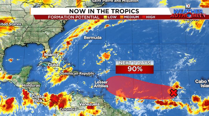
The tropical wave we’ve been following since last Thursday in this newsletter – designated Invest 91L by the National Hurricane Center early Thursday – is expected to become a tropical depression or named storm this weekend and could affect the easternmost islands of the Caribbean by the middle to latter part of next week.
Leer en español

Though showers and thunderstorms remain disorganized, the area of spin has consolidated some since Thursday and more concentrated storminess should get it over the hump sometime this weekend. Intensity guidance suggests only slow organization into early next week and most models keep it at tropical storm strength or weaker during its travels toward the eastern Caribbean.

Euro and AI models downtrend overnight
The big change overnight is a significant downtrend in development from both the European and AI-based Google DeepMind model groups.

Compared with the same run cycle Thursday, the number of ensemble scenarios showing development saw a major drop overnight, with only a handful of members in the European model ensembles and now only one member of Google’s hurricane-specific DeepMind ensemble advertising development.

The American GFS ensembles likewise have seen a slight downtick in ensemble-based development, but to a lesser degree than their European and AI-based counterparts.

It’s worth noting, however, that the ensemble members that do develop 91L in all model camps tend to be on the stronger side, especially by later next week, which could indicate a more conducive environment as it arrives over the western part of the Atlantic basin. It’s also possible the small size of 91L is giving the lower resolution global ensembles trouble, which typically are much less skillful in predicting future intensity than our statistically-based intensity guidance.
Nevertheless, the bearish change on development from our more skillful models is noteworthy and we’ll want to see if that trend continues.
At least for now, sporadic infusions of shear and dry air should pull the reins on any robust development for the next few days. Regardless, the Lesser Antilles westward to the U.S. and British Virgin Islands and Puerto Rico will want to keep close tabs on this one, as the path should take it in the vicinity come next Thursday (September 11th) to Saturday (September 13th).

Too soon to say for the broader U.S.
With higher-than-usual uncertainty even over the next few days, it’s of course not surprising that we can’t say anything yet about whether the system could eventually pose a problem for the mainland U.S.
As we’ve detailed in previous newsletters, a pronounced dip in the jet stream off the eastern U.S. late next week will in general support a turn north of any system approaching from the east. The devil’s in the details, though, and exactly where the system is located late next week and how strong it becomes will dictate how wide or sharp a turn it makes.
The bottom line for now is check back periodically on the forecast, especially come early next week, but for now, a lot would still need to happen before this one becomes an issue for us stateside (if at all).
CLICK HERE to download the Local 10 Weather Authority’s 2025 hurricane survival guide.
Copyright 2025 by WPLG Local10.com – All rights reserved.

