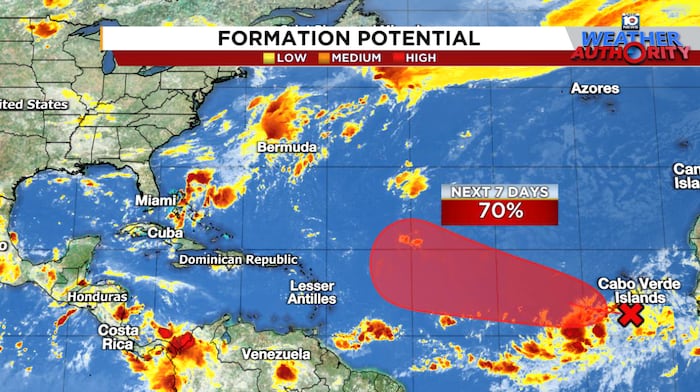
A disturbance over the eastern tropical Atlantic could gradually develop into a tropical depression or named storm by late this week or weekend as it moves generally west to west-northwestward.
While the system will remain over the open Atlantic this week, it could near the islands of the eastern Caribbean by the middle part of next week, so interests in the Leeward Islands should monitor the forecasts in the days ahead.
Models all over the map
Forecast models generally agree on development, but the timing of and placement of development vary wildly, which of course affect the future track.
On the one hand, the American GFS is quick to develop the system this week along the northern lobe of the tropical wave and as a result, move it farther north and turn it quickly into the Atlantic for next week, missing the islands to the north.

On the other hand, the European model and Google DeepMind’s newest machine learning-based model that performed well during Hurricane Erin, take some time to develop the wave and do so on the southern side, which not surprisingly favors a track farther south and west and toward the eastern Caribbean for the middle part of next week.
Either way, environmental conditions should be in a more conducive configuration for development and strengthening as we head deeper into next week, so if it forms farther south and takes a trajectory closer to the islands as the European and Google DeepMind solutions indicate, it could be problematic for island areas.
As for any threat to the U.S. down the line, it’s far too early for even informed speculation. It’s certainly not something anyone in the mainland U.S. needs to be worried about for the foreseeable future, but it’s always good practice during the season to check back periodically for updates.
Atlantic mostly quiet otherwise
The traditional peak of the hurricane season – on which day you’ll most likely find a named storm – is fast approaching, but for now, the system in the eastern Atlantic is the only game in town.

As we’ve mentioned in previous newsletters, we always keep an eye out for tropical mischief along stalled cold fronts in the fall, but for now, the unusually strong cold fronts this week and another one digging into the northern Gulf and western Atlantic next week don’t show signs of any tropical spinoffs.
CLICK HERE to download the Local 10 Weather Authority’s 2025 hurricane survival guide.
Copyright 2025 by WPLG Local10.com – All rights reserved.

